Finally, the last leg of our drive to Negril. Hurricane Ivan put our trip on the back burner for a while but we are going to get there this month. The last time we got as far as Hopewell, that’s only nine miles from Mobay. The rest of the way is 43 more miles. While not as thickly settled, most of what you see is beautiful scenery. As we leave Hopewell, the road hugs the coast displaying still more of the beautiful colors of the Caribbean Sea. Today, the wind is quite gusty. One can see the spray of the waves as they crash along the rocky shore. Truly an awesome sight! As before, there are numerous wooden shacks or shops selling wood carvings, seashells and Jamaican fare along both sides of the road. The further we are from Mobay, the fewer there are.
The first small town is Flint River, named after the river that goes through it. This town is so small, the only way you would recognize it is because of a sign at the bridge which goes over the river. Once you cross the bridge, Tryall’s golf course can be seen on both sides of the road. This golf course has been the sight of several major golf tournaments over the years and is considered one of the best on the island. The resort, itself, sits on a 2,200 acre former sugar plantation and boasts a 165 year old Georgian style Great House.
Sandy Bay is the next town. Most of the homes are simple small wooden structures set on blocks to protect them from the rainwater which runs down the mountain. Sandy Bay is also home to a Jockey factory. Just outside of Sandy Bay, is the home of Chukka Blue Adventure Tours, which includes horseback riding, white water tubing, and a Jeep safari tour. The next small town is Mosquito Cove which is located on a very picturesque cove by the same name. There are four more small towns before we reach Lucea. The closer we get to Lucea, the larger the towns are. They are Paradise, Elgin Town, Kew, and Johnson Town. The last three are on another larger cove called Lucea Harbour.
Lucea is the center of government for Hanover Parish and is located on the west side of the harbour. The road through the center of town becomes a one way road or a very large roundabout (rotary). Lucea is a very bustling town with throngs of people happily going about their business on the very congested streets. The most prominent building is a nineteenth century courthouse with a clock tower over Corinthian style columns. There is also an old fort, named Fort Charlotte, which never fired a cannon shot in its defense, and sits on the edge of the harbour.
As we leave Lucea, the land begins to flatten out. Gone are the high rugged mountains but replaced by gentler hills. From here to our destination is more beautiful country on one side and sea on the other. We pass through three more small towns, Lance’s Bay, Cousin’s Cove, and Davis Cove before we reach Green Island, which isn’t an island. This is the last town before Negril.
A few miles from Green Island you see the first of, what seems like, countless tourist accommodations, beginning with two very large Riu Resorts. On the other side of the road is Negril’s Aerodrome, which accepts prop driven airplanes only. This would be the fastest way of getting to Negril, driving takes an hour or more, depending on which end of town you are staying.
The water along the first section of the famous seven mile beach is famous in its own right. Back in 1720, this was where the pirates Calico Jack, and his girlfriend, Ann Bonney were captured by a British Navy sloop. All of the pirates were hanged except for Ann Bonney who claimed to be pregnant. The law forbade hanging of pregnant women. The name of the bay is Bloody Bay, which didn’t get its name from the pirates but from the whalers, who used to dump the unusable parts of the whales into the bay, thus turning the water red.
The closer we get to the center of town, the more inviting it looks. Shops that sell food, clothing, souvenirs, or almost anything you want are on both sides of the road mingled in between the big all-inclusive resorts, small hotels, night spots, and restaurants. This is called the “East End” of Negril. If you look at a map, however, the “East End” is actually due north of Negril.
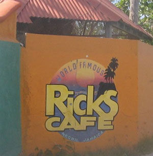
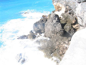
The other end is called the “West End.” I will admit it is further west than the “East End”, hence the name. The only road in this section of town is very narrow and curvy. It is also quite picturesque. Instead of the seven miles of white sand beaches on the “East End”, there are high cliffs with pounding surf spraying water high into the air. There are many accommodations, restaurants, and shops in this part of town, as well. There are several restaurants who offer cliff diving with their fare. The most famous of these, Rick’s Cafe, is still closed because of damage from Hurricane Ivan.
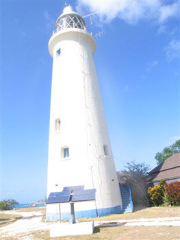
Down the road a little further is the only local landmark of interest, Negril Lighthouse. It sits on top of the cliffs and is as majestic as any found along the New England coast. It was originally powered by oil lamps and then gas, but today, it is solar powered. One of my reference guides says you can climb the 100 steps to the top. When I was there a few weeks ago, I was the only person there. More people must be interested in the sun, fun, and sand than in visiting the lighthouse.
So, our trip to Negril comes to an end. The ride, which is a little over an hour, is easy on Highway 2000. The new highway cuts about 15-20 minutes off the trip. As mentioned previously, the roads through all the towns remain unchanged, as they have been for centuries, and only adds to the beauty of the drive.
I hope you come to Jamaica and “feel alright.” Explore, as I did, all the island has to offer. There’s far more to Jamaica than sun, fun, and sand. Come and see for yourself!